
Mount Gipps, Queensland
| Mount Gipps Queensland | |||||||||||||||
|---|---|---|---|---|---|---|---|---|---|---|---|---|---|---|---|
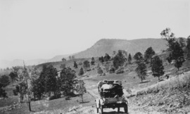 Mount Gipps on McPherson Range, 1928 | |||||||||||||||
 Mount Gipps | |||||||||||||||
| Coordinates | 28°19′20″S 153°00′35″E / 28.3222°S 153.0097°E | ||||||||||||||
| Population | 7 (2016 census)[1] | ||||||||||||||
| • Density | 0.45/km2 (1.15/sq mi) | ||||||||||||||
| Postcode(s) | 4285 | ||||||||||||||
| Area | 15.7 km2 (6.1 sq mi) | ||||||||||||||
| Time zone | AEST (UTC+10:00) | ||||||||||||||
| Location |
| ||||||||||||||
| LGA(s) | Scenic Rim Region | ||||||||||||||
| State electorate(s) | Scenic Rim | ||||||||||||||
| Federal division(s) | Wright | ||||||||||||||
| |||||||||||||||
Mount Gipps is a rural locality in the Scenic Rim Region, Queensland, Australia.[2] In the 2016 census, Mount Gipps had a population of 7 people.[1]
The locality borders New South Wales [3] and is one end of the Queensland rabbit-proof fence.[4]
Geography[edit]
Mount Gipps has high slopes to the south belonging to the McPherson Range and also in the north-east with a valley through the north-west and from west to east.[3] The mountain Mount Gipps, from which the locality takes its name, is on the southern border of the locality with New South Wales (28°20′31″S 152°59′25″E / 28.3419°S 152.9903°E); it rises to 785 metres (2,575 ft) above sea level.[5][3]
Running Creek, a tributary of the Logan River, flows from east to west through the locality. Mount Gipps Road enters from Chinghee Creek in the north-west and follows through the valley. Although entirely freehold land, only the lower valley areas have been cleared and are used for grazing. The slopes have an extensive tree cover.[3]
History[edit]


In 1900, much of the land in the upper reaches of Running Creek was part of the rural property Telemon Crossing owned by A. Drynan.[6]
There was a sawmill in Mount Gipps from at least 1920.[7] It was located in the valley.[8]
Mount Gipps State School was opened on 21 July 1920.[9][10] It closed on 30 June 1954.[11][12] It was at 220 Mount Gipps Road (28°19′19″S 152°59′29″E / 28.3220°S 152.9915°E).[13][3]
In the 2016 census, Mount Gipps had a population of 7 people. The locality contains 8 households, in which 30.0% of the population are males and 70.0% of the population are females with a median age of 52, 14 years above the national average. The average weekly household income is $0, $1,438 below the national average.[1]
Education[edit]
There are no schools in Mount Gibbs. The nearest government primary school is Hillview State School in Hillview to the north. The nearest government secondary school is Beaudesert State High School in Beaudesert further north.[3]
References[edit]
- ^ a b c Australian Bureau of Statistics (27 June 2017). "Mount Gipps (SSC)". 2016 Census QuickStats. Retrieved 20 October 2018.
- ^ "Mount Gipps – locality in Scenic Rim Region (entry 45173)". Queensland Place Names. Queensland Government. Retrieved 29 December 2020.
- ^ a b c d e f "Queensland Globe". State of Queensland. Retrieved 4 May 2020.
- ^ "Information on the Darling Downs-Moreton Rabbit Board". Darling Downs-Moreton Rabbit Board. 28 January 2015. Archived from the original on 26 February 2015. Retrieved 21 August 2015.
- ^ "Mountain peaks and capes - Queensland". Queensland Open Data. Queensland Government. 12 November 2020. Archived from the original on 25 November 2020. Retrieved 25 November 2020.
- ^ "From Lara to Cannon and Knapp's Creek". Queensland Country Life. 25 June 1900. p. 18. Archived from the original on 13 January 2022. Retrieved 26 August 2015 – via National Library of Australia.
- ^ "Meeting at Mount Gipps". The Worker. Brisbane. 25 November 1920. p. 16. Archived from the original on 13 January 2022. Retrieved 26 August 2015 – via National Library of Australia.
- ^ "AT BEAUDESERT". The Brisbane Courier. 27 June 1922. p. 7. Archived from the original on 13 January 2022. Retrieved 26 August 2015 – via National Library of Australia.
- ^ "Public Works". The Telegraph. Brisbane. 10 October 1919. p. 4. Archived from the original on 13 January 2022. Retrieved 26 August 2015 – via National Library of Australia.
- ^ "THE WEEK'S NEWS IN BRIEF". The Week. Brisbane. 4 June 1920. p. 23. Archived from the original on 13 January 2022. Retrieved 26 August 2015 – via National Library of Australia.
- ^ "Opening and closing dates of Queensland Schools". Queensland Government. Retrieved 26 August 2015.
- ^ "Agency ID 9136, Mount Gipps State School". Queensland State Archives. Retrieved 26 August 2015.
- ^ "Queensland Two Mile series sheet 2m4" (Map). Queensland Government. 1946. Archived from the original on 13 January 2022. Retrieved 13 January 2022.
External links[edit]
- "Macpherson Range". The Week. Brisbane. 26 July 1929. p. 8. Retrieved 26 August 2015 – via National Library of Australia. — a description of the MacPherson Ranges in 1929, including Mount Gipps area