
Kleine Kahl
| Kleine Kahl | |
|---|---|
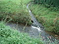
 The Kleine Kahl before Kleinkahl | |
| Location | |
| Country | Germany |
| State | Bavaria |
| Physical characteristics | |
| Source | |
| • location | near Kleinkahl |
| • coordinates | 50°05′36″N 9°18′39″E / 50.093232°N 9.310859°E |
| Mouth | |
• location | in Kleinkahl in the Kahl |
• coordinates | 50°06′24″N 9°16′29″E / 50.106661°N 9.274711°E |
| Length | ca. 3.5 km |
| Basin features | |
| Progression | Kahl→ Main→ Rhine→ North Sea |
The Kleine Kahl ("Little Kahl") is a left tributary of the Kahl in the northern Spessart in Lower Franconia, Bavaria, Germany.[1] The spring is located about 2 km southeast of Kleinkahl. In this community it flows into the Kahl.
-
 The spring of the Kleine Kahl
 -
 Mouth in the Kahl


References[edit]
- ^ "Durchs Tal der Kleinen Kahl". GPS-Wanderatlas (in German). Retrieved 2022-12-25.
Wikimedia Commons has media related to Kleine Kahl.