
Geraldine Peak
| Geraldine Peak | |
|---|---|
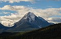
 Geraldine Peak seen from Whirlpool River | |
| Highest point | |
| Elevation | 2,930 m (9,610 ft)[1] |
| Prominence | 710 m (2,330 ft)[1] |
| Parent peak | Mount Fryatt 3361 m[1] |
| Listing | Mountains of Alberta |
| Coordinates | 52°36′26″N 117°57′25″W / 52.60722°N 117.95694°W[1] |
| Geography | |
 Geraldine Peak Location in Alberta  Geraldine Peak Geraldine Peak (Canada) | |
| Location | Alberta, Canada |
| Parent range | Canadian Rockies |
| Topo map | NTS 83C12 Athabasca Falls[1] |
| Climbing | |
| Easiest route | Scrambling |
Geraldine Peak is a 2,930-metre (9,610-foot) mountain summit located in the Athabasca River valley of Jasper National Park, in the Canadian Rockies of Alberta, Canada. The peak is also known as Whirlpool Mountain,[2][3] and Mount Geraldine.[4] No name has been officially adopted yet. The names derive from its position at the northern end of the long ridge that divides Geraldine Lakes[5] and Geraldine Creek on the southeast side, from the Whirlpool River on the northwest side. The nearest higher peak is Mount Fryatt, 7.0 km (4.3 mi) to the south-southeast.[1] Geraldine Peak can be seen from the Icefields Parkway in the vicinity of Athabasca Falls.
Climate[edit]
Based on the Köppen climate classification, Geraldine Peak is located in a subarctic climate with cold, snowy winters, and mild summers.[6] Temperatures can drop below -20 °C with wind chill factors below -30 °C. Precipitation runoff from Geraldine Peak drains into tributaries of the Athabasca River.
Geology[edit]
The mountain is composed of sedimentary rock laid down during the Precambrian to Jurassic periods and pushed east and over the top of younger rock during the Laramide orogeny.[7]
Gallery[edit]
-
 Whirlpool Mountain (left) and Mount Edith Cavell (right) seen with Athabasca River
 -
 Whirlpool Mountain reflected in Leech Lake
 -
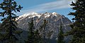
 Whirlpool Mountain
 -
 Mount Fryatt outlier (left) and Whirlpool Mountain (right)
 -
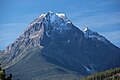
 Geraldine Peak
 -
 Geraldine Peak
 -
 Geraldine Peak


See also[edit]
References[edit]
- ^ a b c d e f "Geraldine Peak". Bivouac.com. Retrieved 2018-12-12.
- ^ Thorington, J. Monroe (1925). The Glittering Mountains of Canada. Rocky Mountain Books. p. 171.
- ^ Birrell, Dave (2000). 50 Roadside Panoramas in the Canadian Rockies. Rocky Mountain Books. pp. 28–29.
- ^ Dougherty, Sean (1991). Selected Alpine Climbs in the Canadian Rockies. Rocky Mountain Books. p. 252.
- ^ "Geraldine Lakes". Geographical Names Data Base. Natural Resources Canada. Retrieved 2018-12-13.
- ^ Peel, M. C.; Finlayson, B. L.; McMahon, T. A. (2007). "Updated world map of the Köppen−Geiger climate classification". Hydrol. Earth Syst. Sci. 11: 1633–1644. ISSN 1027-5606.
- ^ Gadd, Ben (2008), Geology of the Rocky Mountains and Columbias
External links[edit]
- Parks Canada web site: Jasper National Park
- Climbing Geraldine Peak: Giant's Gate Journeys
Places adjacent to Geraldine Peak | ||||||||||||||||
|---|---|---|---|---|---|---|---|---|---|---|---|---|---|---|---|---|
| ||||||||||||||||