
2013 Midwestern U.S. floods
.jpg) Flooding along the Des Plaines river on April 18, 2013 | |
| Cause | Heavy rains |
|---|---|
| Meteorological history | |
| Duration | April 17, 2013 – April 18, 2013 |
| Flood | |
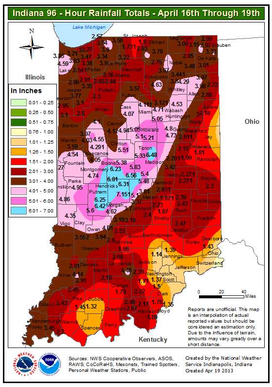
| Maximum rainfall | 7.151 in (181.6 mm) in Hendricks County, Indiana[1][2] |
| Overall effects | |
| Fatalities | 5 |
| Injuries | 3 |
| Damage | >$371 million |
| Areas affected | Midwestern United States, particularly Illinois, Michigan, Indiana, eastern Missouri, eastern North Dakota |
In April 2013, persistent heavy rains caused widespread flooding, primarily impacting the Midwestern and Great Lakes regions. In a span of two days on April 17 and 18, heavy rainfall associated with a slow-moving storm system caused widespread flooding across rivers and areas, where rainfall amounts over 8 inches (200 mm) caused rivers to swell and crest, including the Mississippi River and the Red River, with the latter river dealing with melting ice caps.[3][4] The Grand River crested to a record level, prompting water rescues and evacuations in Grand Rapids, Michigan.[5] A local state of emergency was declared for the city of Des Plaines, Illinois after the Des Plaines River swelled to 10.92 feet (3,330 mm). The governors of Illinois and Missouri declared state of emergencies, and the Federal Emergency Management Agency declared a federal emergency and a disaster declaration for 46 counties in Illinois. Five fatalities occurred: two each in Illinois and Indiana, with a fifth in Missouri. Three others were injured, all in Illinois.
Meteorological synopsis[edit]

An upper-level trough which was situated over the Great Lakes and Midwest regions moved into the Northeastern United States before being replaced by a strong ridge of high pressure over the Southeastern United States.[3] This resulted in moisture being transported to the Great Lakes and Midwest regions, and upper-air weather soundings conducted by the National Weather Service Lincoln, Illinois, showed precipitable water values around 1.50 inches.[3]
On April 17, a cold front approached the Midwest, pushing eastward towards the transported mass of moisture. However, the frontal boundary became parallel to a southwesterly upper flow and stalled over the Mississippi River.[3] Trained thunderstorms along a quasi-stationary boundary front[6] produced heavy rainfall across the Midwest before the storms headed eastward.[3][7] The day after, an outflow boundary associated with the cold front caused additional thunderstorm development across the same areas that were saturated the day before.[3] This resulted in flooding across east-central Illinois and western Indiana before an upper-level trough pushed the cold front eastward.[3][8]
Preparations[edit]
Volunteers and construction workers built emergency sand dikes and earthened levees in the Fargo, North Dakota–Moorhead, Minnesota, area.[9][10] More than 400,000 sandbags were set up in the Moorhead area.[11] Residents in Fargo, North Dakota began filling more than 750,000 sandbags to aid in protection from the floods.[12] Prior to the flood event, a severe drought occurred across areas near the Red River.[13]
In Missouri, areas along the Mississippi River placed sandbag levees and makeshift barriers.[3] Prison inmates were driven to Clarksville to assist in building a floodwall of gravel and sand.[14] The Missouri National Guard assisted with sandbag preparation efforts near Dutchtown.[15]
In Solon, Iowa, sandbags were set up, and three pumps were delivered by the Department of Public Works.[16] In Naperville, Illinois, North Central College cancelled classes and was closed on August 18.[17] In Chicago, Major League Baseball decided to postpone a Cubs game against the Texas Rangers.[18] Near Vincennes, Indiana, floodgates were installed to prevent the nearby Wabash River from overflowing, and added sandbags along portions of the river.[15]
Impact[edit]
Illinois[edit]
.jpg)
.jpg)
In Des Plaines, at least 800 homes and businesses were impacted, and 60 water rescues occurred.[4] Residences were evacuated around Big Bend Lake in Des Plaines, and the Des Plaines River swelled 10.92 feet (3,330 mm),[19] breaking the 1986 crest level record by 0.02 inches,[20] and prompting a local state of emergency for Des Plaines.[21] In Chicago, 3.54 inches (90 mm) of rain fell, which would add to the city's rainfall total to 8.54 inches (217 mm)–which was recorded as the wettest April on record in Chicago.[22] Portions of the Kennedy, Edens, Eisenhower, Bishop Ford and Dan Ryan expressways were shut down,[23][24] and a flash flood warning was issued for the city of Chicago.[25] A portion of Interstate 74 shut down in Peoria and Tazewell counties.[26] Chicago emergency management received more than 1,500 calls of flooding.[25] Heavy rainfall filled the underground system of the Chicago River, which forced the river flow to be reversed to Lake Michigan.[27][28]
In Clarendon Hills, homes and yards sustained "devastating" damage,[29] while in downtown Naperville, streets were flooded and schools were cancelled the next day on April 19 because of flooding concerns.[30][17] A branch of the DuPage River spilled over a levee protecting the river flooding, and a hospital in Morris evacuated 44 patients after floodwaters entered the basement of the hospital.[31] In Utica, a mobile home park was evacuated, while water rescues were conducted in Marshall County.[31] A levee breached in Lincolnshire, prompting 49 homes to be evacuated, and in Marseilles, 1,500 people were evacuated after a compromised levee flooded homes and infrastructure.[26] Several homes were also evacuated in London Mills as numerous homes were inundated by floodwaters.[26] Several streets and a parking lot at Scott Air Force Base was flooded.[32][33][34] In Peoria, the city broke their 24-hour rainfall record, while Galesburg set a daily rainfall record on April 18, with 4.16 inches (106 mm).[3]
The Illinois River near Peoria crested to 29.35 feet (895 cm) on April 23,[35] which broke a crest record set 70 years prior, and 20 to 30 homes and businesses near the river were evacuated.[15] The Illinois River at Henry was crested to a record 32.87 feet (10.02 m) on April 22,[36] and the river at Beardstown crested to a record 29.81 feet (9.09 m) on April 27.[37] The Illinois River at La Grange crested to a record 34.50 feet (10.52 m) on April 27, and some locations along the Kaskaskia, La Moine, Illinois, and Mississippi rivers hit major flood levels, with the latter two remaining above flood levels through the next month.[38] Mudslides were also reported along the bluffs of the Illinois River in Peoria and Tazewell counties, covering U.S. Route 150 with several inches of mud and damaging a gas station in Tazewell County.[39][40] All roads in Stark and Woodford counties were flooded as water rescues were conducted.[41][42] Record flooding along the Spoon River in Fulton County damaged 40 homes in Bernadotte Township, Seville, and London Mills, with the downtown area of the latter location completely inundated by flash flooding caused by a levee breach along the river.[43] Additional levees were breached along the river, resulting in thousands of acres of agricultural land, county roads, and nature preserves flooded.[43] The Spoon River crested to a record 35.83 feet (10.92 m) in Seville on April 20, breaking the previous record crest by nearly 3 feet (0.91 m) and also was nearly 14 feet (4.3 m) above flood stage.[43] The flooding caused a river gauge in London Mills to be disabled, and flooding along the Illinois River stemming from the April floods continued into the next month.[43] The La Moine River crested to a record 32.54 feet (9.92 m) in Ripley on April 21, and the river did not subside below flood levels until April 26.[44] At Beall Woods State Park, more than 100 acres (0.16 sq mi) was flooded, and extensive flooding occurred across northern Mount Carmel, with all but one local road east of a levee along the Wabash River flooded.[45] The Wabash River near Mount Carmel also crested to 30.24 feet (9.22 m), which was the thirteenth-highest crest on record.[45]
Two deaths occurred, one in Oak Brook and the other in Cora.[46] Two injuries occurred when two homes collapsed into a basement in Peoria.[26] One person in Chicago was hospitalized after their vehicle, along with two parked cars, was swallowed into a sinkhole.[31] 550 flights were cancelled at O'Hare International Airport, while an additional 30 were cancelled at Midway International Airport.[47][31] Floods damaged thousands of homes and structures across the state, and flood and hail damages totaled in excess of $371 million.[26][48]
Michigan[edit]

The Grand River crested to a record 21.85 feet, breaking a 1985 river crest record, forcing evacuations and flooding downtown Grand Rapids.[49] 9.1 inches (230 mm) of rainfall fell in Grand Rapids on April 18, breaking the previous rainfall record set in 1909.[50] Sandbags were set up in downtown Grand Rapids along the Grand River, and 1,000 people were evaucated from the Plaza Towers.[51] The Grand Rapids Public Museum was shut down after floodwaters surrounded the museum, despite sandbags that were set up around the building.[52][53] The Grand River also flooded areas of Lowell and Ada Township and prompted evacuations in Wyoming for 25 homes.[31][54][55] Buck Creek was flooded, leading to evacuations across Grandville,[56] and minor flooding occurred along the Saginaw River.[57] Parts of Shiawassee National Wildlife Refuge was flooded, and water topped the dike at Misteguay Creek in Saginaw County.[15] Homes and businesses along the Tittabawassee River were flooded.[15] Grand Rapids mayor George Heartwell declared a local state of emergency after low-lying areas in the city were inundated, forcing people to evacuate.[58]
Indiana[edit]

Roads were flooded in downtown Indianapolis, and schools were closed in Zionsville and Lebanon.[59] Two car crashes occurred on Interstate 465 and Interstate 65 after rain caused vehicles to hydroplane. A water rescue occurred in Brownsburg, and vehicles were inundated and stranded in Carmel and Westfield.[59] The thunderstorms accompanying the heavy rain caused a lightning strike which damaged a US Airways plane on the runway at Indianapolis International Airport, according to airport officials, and another lightning strike damaged three homes in Hamilton County.[60] Numerous creeks and rivers, including the Wabash River, crested above major flood levels.[61] Flooding forced sandbags to be placed along the Little Calumet River and cancelled a flood-fighting drill in Gary.[31] Two fatalities occurred when they were swept away by floodwaters along a crested Cicero Creek.[46][62]
Missouri[edit]
In Ava, children and a bus driver were rescued after their school bus was surrounded by floodwaters.[31] De Soto was flooded, resulting in nearly 5,000 power outages across the city.[63] Near St. Louis, 114 barges were loosened, with some hitting Jefferson Barracks Bridge, forcing the bridge to close.[46] Nearly 300 state roads were closed according to the Missouri Department of Transportation.[64][65] Six levees north of St. Louis along the Mississippi River were overtopped.[15] A woman was killed after she was swept away by a swelled Joachim Creek.[66]
North Dakota[edit]
The Red River overflowed due to leftover melting snow caused by the heavy rainfall, which posed a flood threat to Fargo.[67] However, temporary levees prevented significant flood damage. Fargo mayor Dennis Walaker recalled after the flood event, "Four floods in the last five years. That's extremely unusual."[68]
Aftermath[edit]
.jpg)
Illinois governor Pat Quinn, Missouri governor Jay Nixon, and Michigan governor Rick Snyder declared a state of emergency, with Snyder extending the emergency until May 25.[69][70][71] The Missouri National Guard was dispatched to the Mississippi River in Clarksville and Dutchtown,[72] and Nixon activated the Missouri State Emergency Operations Plan, providing emergency service via state agencies to coordinate with jurisdictions.[73] Illinois governor Quinn designated 44 counties in Illinois as disaster areas.[67] The Federal Emergency Management Agency declared a federal emergency and a disaster declaration for 46 counties in Illinois.[74][19] On December 18, 2014, two law enforcement officers from the Missouri State Highway Patrol were honored by the Missouri Department of Public Safety after rescuing two people from flooding.[75]
References[edit]
- ^ "Indiana precipitation totals for April 18, 2013 flood event". NWS Indianapolis. April 19, 2013. Archived from the original on March 30, 2021. Retrieved August 22, 2023.
- ^ US Department of Commerce, NOAA. "April 18-19, 2013 Heavy Rain and Flooding". www.weather.gov. Archived from the original on August 17, 2023. Retrieved August 17, 2023.
- ^ a b c d e f g h i National Oceanographic and Atmospheric Administration. "Record River Flooding of April 2013". Weather.gov. Archived from the original on August 15, 2023. Retrieved August 15, 2023.
 This article incorporates text from this source, which is in the public domain.
- ^ a b Davey, Monica (April 26, 2013). "In Midwest, Drought Gives Way to Flood". The New York Times. Archived from the original on December 17, 2019. Retrieved August 15, 2023.
- ^ mvandebu@mlive.com, Matt Vande Bunte | (January 5, 2014). "2013 Flood: Experts describe how close Grand Rapids was to crippling floodwall breach". MLive. Archived from the original on August 15, 2023. Retrieved August 15, 2023.
- ^ Otto, Walter (April 17, 2013). "Mesoscale Precipitation Discussion 13 (2013)". Weather Prediction Center. Retrieved October 16, 2023.
- ^ US Department of Commerce, NOAA. "Severe Weather April 18, 2013". www.weather.gov. Archived from the original on August 22, 2023. Retrieved August 22, 2023.
- ^ Rubin-Oster, Brendon (April 18, 2013). "Mesoscale Precipitation Discussion 16 (2013)". Weather Prediction Center. Retrieved October 16, 2023.
- ^ "Red River flood preparations in high gear in Fargo-Moorhead". Twin Cities. Associated Press. April 22, 2013. Archived from the original on August 27, 2023. Retrieved August 27, 2023.
- ^ "Fargo starts temporary levee construction ahead of flood". MPR News. April 22, 2013. Archived from the original on August 15, 2023. Retrieved August 27, 2023.
- ^ "Moorhead Ready For Flooding With 400,000 Sandbags". CBS Minnesota. CBS News. April 18, 2013. Archived from the original on August 16, 2023. Retrieved August 16, 2023.
- ^ "Fargo, North Dakota, braces for major Red River flooding". Reuters. April 4, 2013. Archived from the original on August 15, 2023. Retrieved August 15, 2023.
- ^ "Sandbag Season Has Fargo Thinking of a Better Way". The New York Times. April 2, 2013. Archived from the original on July 14, 2019. Retrieved August 15, 2023.
- ^ Johnston, Ian (April 23, 2013). "After Deadly Flooding, More Rain and Snow Falls on Midwest". CNBC. Archived from the original on August 15, 2023. Retrieved August 15, 2023.
- ^ a b c d e f "Illinois River floodwaters top 70-year record: 'That's our nightmare'". The Guardian. Associated Press. April 24, 2013. ISSN 0261-3077. Archived from the original on December 2, 2022. Retrieved August 27, 2023.
- ^ "Sandbagging in Solon as Eastern Iowa Braces Against Flooding". Iowa Public Radio. April 18, 2013. Archived from the original on August 16, 2023. Retrieved August 16, 2023.
- ^ a b "Naperville Flooding Updates: D203, D204 Cancel School; Bridges Reopen". Naperville, IL Patch. April 18, 2013. Archived from the original on August 19, 2023. Retrieved August 19, 2023.
- ^ "Cubs Game Against Rangers Postponed Due To Weather". CBS Chicago. April 17, 2013. Archived from the original on August 27, 2023. Retrieved August 23, 2023.
- ^ a b "Post Flood Survey Report: April 2013 Chicago Area Riverine and Basement Flooding" (PDF). United States Army Corps of Engineers. April 2017. Archived (PDF) from the original on August 16, 2023. Retrieved August 16, 2023.
- ^ "When April showers went on a rampage: Record-breaking floods in the Chicago area". National Aeronautics and Space Administration. February 18, 2021. Archived from the original on August 16, 2023. Retrieved August 16, 2023.
- ^ "Flood waters rise dangerously fast in Des Plaines". Chicago Tribune. April 18, 2013. Archived from the original on August 15, 2023. Retrieved August 15, 2023.
- ^ Samenow, Jason (April 24, 2013). "Chicago logs wettest April on record, Midwest rivers swell". The Washington Post. Archived from the original on October 28, 2021. Retrieved August 15, 2023.
- ^ "Storm Events Database - Event Details". National Centers for Environmental Information. Retrieved December 12, 2023.
- ^ "Storm Events Database - Event Details". National Centers for Environmental Information. Retrieved December 12, 2023.
- ^ a b "State Of Emergency: Massive Rains Create Widespread Flooding". CBS Chicago. CBS News. April 18, 2013. Archived from the original on August 16, 2023. Retrieved August 16, 2023.
- ^ a b c d e US Department of Commerce, NOAA. "Flooding in Illinois". www.weather.gov. Archived from the original on August 22, 2023. Retrieved August 22, 2023.
- ^ Balde, Lisa (April 18, 2013). "Chicago Re-Reverses River To Handle Flooding". NBC Chicago. Retrieved December 12, 2023.
- ^ "Storm Events Database - Event Details". National Centers for Environmental Information. Retrieved December 12, 2023.
- ^ Burke, Christopher (July 2013). "Village of Clarendon Hills April 18, 2013 Storm Event Clarendon Hills, DuPage County, Illinois". Village of Clarendon Hills. Archived from the original on July 7, 2022. Retrieved August 16, 2023.
- ^ "Naperville hit with heavy rain, flooding". Chicago Tribune. April 18, 2013. Archived from the original on August 16, 2023. Retrieved August 16, 2023.
- ^ a b c d e f g "From Rockies to Rust Belt, storm brings extremes". The Times Herald. April 18, 2013. Archived from the original on August 18, 2023. Retrieved August 17, 2023.
- ^ O'Neil, Tim (April 18, 2013). "Flash flooding overwhelms roads, displaces residents in Jefferson County and Illinois". STLtoday.com. Archived from the original on August 25, 2023. Retrieved August 25, 2023.
- ^ "Scott Air Force Base battles flood". Scott Air Force Base. April 18, 2013. Retrieved August 25, 2023.
- ^ "Storm Events Database - Event Details". National Centers for Environmental Information. Retrieved December 12, 2023.
- ^ "Storm Events Database - Event Details". National Centers for Environmental Information. Retrieved December 12, 2023.
- ^ "Storm Events Database - Event Details". National Centers for Environmental Information. Retrieved December 12, 2023.
- ^ "Storm Events Database - Event Details". National Centers for Environmental Information. Retrieved December 12, 2023.
- ^ "Storm Events Database - Event Details". National Centers for Environmental Information. Retrieved December 12, 2023.
- ^ "Storm Events Database - Event Details". National Centers for Environmental Information. Retrieved December 12, 2023.
- ^ "Storm Events Database - Event Details". National Centers for Environmental Information. Retrieved December 12, 2023.
- ^ "Storm Events Database - Event Details". National Centers for Environmental Information. Retrieved December 12, 2023.
- ^ "Storm Events Database - Event Details". National Centers for Environmental Information. Retrieved December 12, 2023.
- ^ a b c d "Storm Events Database - Event Details". National Centers for Environmental Information. Retrieved December 12, 2023.
- ^ "Storm Events Database - Event Details". National Centers for Environmental Information. Retrieved December 12, 2023.
- ^ a b "Storm Events Database - Event Details". National Centers for Environmental Information. Retrieved December 12, 2023.
- ^ a b c "Rivers crest across Midwest; more rain in forecast". AP News. Associated Press. April 21, 2013. Archived from the original on August 15, 2023. Retrieved August 15, 2023.
- ^ "Flood Warnings in Midwest Follow Storms, Torrential Rain". NBC Connecticut. April 18, 2013. Archived from the original on August 15, 2023. Retrieved August 15, 2023.
- ^ "Storm Events Database - Search Results". National Centers for Environmental Information. Retrieved December 12, 2023.
- ^ "Grand River In West Michigan Breaks Record Levels". CBS News. Associated Press. April 22, 2013. Archived from the original on August 27, 2023. Retrieved August 27, 2023.
- ^ McMillin, Zane (April 18, 2013). "104-year-old April rainfall record shattered in Grand Rapids, with more downpours likely". MLive. Archived from the original on August 16, 2023. Retrieved August 16, 2023.
- ^ Rent, Andy (April 21, 2022). "Remembering the Grand Rapids Floods of 2013". 100.5 The River. Archived from the original on August 16, 2023. Retrieved August 16, 2023.
- ^ McMillin, Zane (April 21, 2013). "Carousel goes silent: Grand Rapids museum shuts it down for flooding concerns". MLive. Archived from the original on August 16, 2023. Retrieved August 16, 2023.
- ^ Kaczmarczyk, Jeffrey (April 19, 2013). "Sandbagging underway at Grand Rapids Public Museum, declared a 'near priority' to safeguard". Live. Archived from the original on August 16, 2023. Retrieved August 16, 2023.
- ^ LaPonsie, Maryalene (March 1, 2018). "Comparing the 2013 and 2018 Lowell Floods". Lowell's First Look. Archived from the original on August 16, 2023. Retrieved August 16, 2023.
- ^ "Grand Rapids Flooding 2013". Michigan Sweet Spot. April 19, 2013. Archived from the original on August 16, 2023. Retrieved August 16, 2023.
- ^ "A look back at the flood of 2013". Walker, Michigan: WZZM-TV. February 23, 2018. Archived from the original on August 27, 2023. Retrieved August 16, 2023.
- ^ "Flooding in Michigan". earthobservatory.nasa.gov. April 23, 2013. Archived from the original on August 16, 2023. Retrieved August 16, 2023.
- ^ Press, Elisha Anderson, Detroit Free. "Mich. city declares emergency as flooding continues". USA TODAY. Archived from the original on October 7, 2022. Retrieved August 27, 2023.
{{cite web}}: CS1 maint: multiple names: authors list (link) - ^ a b "Rain closes central Indiana roads". wthr.com. April 18, 2013. Archived from the original on August 16, 2023. Retrieved August 16, 2023.
- ^ admin (April 18, 2013). "Severe Storms Dump Heavy Rain, Large Hail on Indiana". Claims Journal. Archived from the original on August 16, 2023. Retrieved August 16, 2023.
- ^ US Department of Commerce, NOAA. "April 18-19, 2013 Heavy Rain and Flooding". Weather.gov. Archived from the original on August 17, 2023. Retrieved August 17, 2023.
- ^ "Midwest Floods Spring 2013 – FloodList". Floodlist.com. Archived from the original on August 16, 2023. Retrieved August 16, 2023.
- ^ "De Soto hit hard by flash flooding; water rescues underway, power out". Leader Publications. April 18, 2013. Archived from the original on August 15, 2023. Retrieved August 15, 2023.
- ^ "Numerous Missouri roads close because of flooding". News Tribune. April 18, 2013. Archived from the original on August 17, 2023. Retrieved August 17, 2023.
- ^ "Heavy rains flood Tri-State roads, many impassable". KHQA. April 18, 2013. Archived from the original on August 17, 2023. Retrieved August 17, 2023.
- ^ "Severe Weather and Flash Flooding April 17th-18th, 2013" (PDF). National Weather Service St. Louis, Missouri. Archived (PDF) from the original on November 23, 2021. Retrieved August 15, 2023.
- ^ a b Castillo, Mariano; Myers, Chad (April 23, 2013). "An inch of rain threatens to bring more big problems to the heartland". CNN. Archived from the original on August 15, 2023. Retrieved August 15, 2023.
- ^ "North Dakota residents exhausted from multiple floods". CBS News. May 2, 2013. Archived from the original on August 16, 2023. Retrieved August 16, 2023.
- ^ Wilson, Rick (April 25, 2013). "Flooding update: Kent County's total damage still being assessed". MLive. Archived from the original on August 16, 2023. Retrieved August 16, 2023.
- ^ Vande Bunte, Matt (April 30, 2013). "$5 million flood damage estimate in Grand Rapids: State of emergency extended". MLive. Archived from the original on August 16, 2023. Retrieved August 16, 2023.
- ^ "Missouri And Illinois Under Disaster Declarations Due To Flooding". STLPR. April 18, 2013. Archived from the original on August 15, 2023. Retrieved August 27, 2023.
- ^ "Missouri Guard units providing flood response along Mississippi River". United States Army. Archived from the original on August 15, 2023. Retrieved August 15, 2023.
- ^ Griffin, Marshall (April 18, 2013). "Missouri And Illinois Under Disaster Declarations Due To Flooding". STLPR. Archived from the original on August 15, 2023. Retrieved August 15, 2023.
- ^ "Amendment No. 4". Federal Emergency Management Agency. June 13, 2013. Archived from the original on August 16, 2023. Retrieved August 16, 2023.
- ^ "Department of Public Safety - Missouri Public Safety Medals". Missouri Department of Public Safety. Archived from the original on August 16, 2023. Retrieved August 16, 2023.