Danxia Town
This article needs additional citations for verification. (January 2024) |
Danxia
丹霞镇 | |||||||
|---|---|---|---|---|---|---|---|
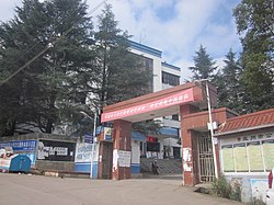
 The government building of Danxia Town. | |||||||
Coordinates: 25°41′10″N 104°36′49″E / 25.68611°N 104.61361°E
 | |||||||
| Country | People's Republic of China | ||||||
| Province | Guizhou | ||||||
| Prefecture-level city | Liupanshui | ||||||
| County-level city | Panzhou | ||||||
| Area | |||||||
| • Total | 175.35 km2 (67.70 sq mi) | ||||||
| Population (2017) | |||||||
| • Total | 48,962 | ||||||
| • Density | 280/km2 (720/sq mi) | ||||||
| Time zone | UTC+08:00 (China Standard) | ||||||
| Postal code | 561601 | ||||||
| Area code | 0858 | ||||||
| Chinese name | |||||||
| Simplified Chinese | 丹霞镇 | ||||||
| Traditional Chinese | 丹霞鎮 | ||||||
| |||||||

Danxia (Chinese: 丹霞镇) is a town in Panzhou, Guizhou, China.[1] As of the 2017 census it had a population of 48,962 and an area of 175.35-square-kilometre (67.70 sq mi).
History[edit]
On June 4, 2015, Shuitang Town (水塘镇) and some parts of Banqiao Town (板桥镇) were merged to form a new town named "Danxia".
Administrative division[edit]
As of December 2015, the town is divided into 14 villages and 1 community:
- Banqiao Community (板桥社区)
- Sanzhai (三寨村)
- Lijiawan (李家湾村)
- Meizichong (梅子冲村)
- Beiyinjing (背阴箐村)
- Zhaoguantun (赵官屯村)
- Shunjutun (顺居屯村)
- Shuitang (水塘村)
- Guoguan (郭官村)
- Huangnitian (黄泥田村)
- Qiansuo (前所村)
- Mulong (木龙村)
- Taoyuan (桃园村)
- Huangba (荒坝村)
- Waishanlan (外山岚村)
- Lishanlan (里山岚村)
- Tiechang (铁厂村)
- Hetaoshu (核桃树村)
- Shadipo (沙地坡村)
- Cangpukeng (苍蒲坑村)
- Pingchuan (坪川村)
Economy[edit]
The town's economy is based on nearby coal reserves and agricultural resources. Potatoes are the main crop.
Transportation[edit]
The S77 Expressway and Provincial Highway S212 pass across the town north to south.
Attractions[edit]
The Huguo Temple is a Buddhist temple in the town.
See also[edit]
References[edit]
- ^ Luan Xiaolin (栾小琳) (17 April 2019). 盘州市丹霞镇开展毒品预防教育进景区宣传活动. xinhuanet (in Chinese). Archived from the original on 17 April 2019. Retrieved 11 December 2019.
