Col des Issartets
| Col des Issartets | |
|---|---|
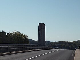
 Marker at the Col des Issartets at the intersection between the motorway and the departmental road. | |
| Elevation | 1,123 m (3,684 ft) |
| Traversed by | D 53, D 809, A 75 |
| Location | Lozère department, France |
| Range | Aubrac (Massif Central) |
| Coordinates | 44°38′57″N 03°14′52″E / 44.64917°N 3.24778°E |
The Col des Issartets is a mountain pass, both a road and a motorway pass, located in the Massif Central on the Aubrac plateau, in the department of Lozère. This pass on the A75 motorway reaches an altitude of 1,123 meters (1,125 meters for the departmental road passing over the bridge), making it the highest motorway pass in France.[1][2]
Geography[edit]
The pass marks the administrative boundary between the municipalities of Sainte-Colombe-de-Peyre to the north and Le Buisson to the south. It is located not far from Lac du Moulinet, a highly frequented water recreation area in the Marvejols region.[3]
References[edit]
- ^ "Autoroute A 75 (France) (Saint-Flour/Grenier-Montgon, 2014)". Structurae (in French). Retrieved 2024-05-01.
- ^ Collectif (2021-06-10). Routes légendaires en Europe (in French). Ulysse. ISBN 978-2-7658-7721-9.
- ^ "LE LAC DU MOULINET TOUT EN NATURE - LE BUISSON". Lozère Tourism | Official tourism website to organise your holiday in Lozère, France. Retrieved 2024-05-01.
External links[edit]
![]() Media related to Col des Issartets at Wikimedia Commons
Media related to Col des Issartets at Wikimedia Commons

