Wanping Subdistrict
Wanping Subdistrict
宛平街道 | |
|---|---|
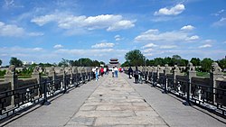
 Wanpingcheng Gate as seen from Marco Polo Bridge, 2016 | |
| Coordinates: 39°51′04″N 116°12′32″E / 39.85111°N 116.20889°E | |
| Country | China |
| Municipality | Beijing |
| District | Fengtai |
| Village-level Divisions | 10 communities 3 village |
| Area | |
| • Total | 19.3 km2 (7.5 sq mi) |
| Population (2020) | |
| • Total | 46,208 |
| • Density | 2,400/km2 (6,200/sq mi) |
| Time zone | UTC+8 (China Standard) |
| Postal code | 100165 |
| Area code | 010 |
Wanping Subdistrict (Chinese: 宛平街道; pinyin: Wǎnpíng Jiēdào), formerly known as Wanpingcheng Area, is a subdistrict in the northern part of Fengtai District, Beijing, China. It borders Lugu Subdistrict to the north, Lugouqiao Subdistrict and Huaxiang Township to the east, Huangcun Township to the south, Changyang Town and Changxindian Town to the west. The subdistrict had a population of 46,208 as of the 2020 census.[1]
The name of the subdistrict came from Wanping, an old city that was first created around here in 1637.[2]
History[edit]
| Time | Status |
|---|---|
| Ming dynasty | Created as Gongji City |
| Qing dynasty | Renamed to Gongbei City |
| 1928 | Transferred Beijing to Hebei, renamed to Wanping after the county that hosted its government |
| 1937 | On the night of July 7, Imperial Japanese Army demanded to enter this region on pretense of searching for a missing Japanese soldier, and the refusal of which led to the outbreak of Second Sino-Japanese War. |
| 1949 | Transferred back to Beijing as part of other subdivisions |
| 1992 | Created as Wanpingcheng Subdistrict (Area) |
| 2002 | Incorporated Laozhuangzi Township |
| 2021 | Area status was revoked and renamed to Wanping Subdistrict, incorporated Lugouqiao Village |
Administrative Division[edit]
Until 2021, 13 subdivision constituted the Wanping Subdistrict, including 10 communities and 3 villages:[3]
| Administrative Division Code | Community Names | Name Transliteration | Type |
|---|---|---|---|
| 110106014001 | 城北 | Chengbei | Community |
| 110106014002 | 宛平城 | Wanpingcheng | Community |
| 110106014003 | 城南 | Chengnan | Community |
| 110106014004 | 晓月苑 | Xiaoyueyuan | Community |
| 110106014005 | 老庄子 | Laozhuangzi | Community |
| 110106014006 | 晓月苑第二 | Xiaoyueyuan Di'er | Community |
| 110106014007 | 沸城 | Feicheng | Community |
| 110106014008 | 城南第二 | Chengnan Di'er | Community |
| 110106014009 | 景园 | Jingyuan | Community |
| 110106014010 | 宛平城东关 | Wanpingcheng Dongguan | Community |
| 110106014201 | 永合庄 | Yonghezhuang | Village |
| 110106014202 | 北天堂 | Beitiantang | Village |
| 110106014203 | 卢沟桥 | Lugouqiao | Village |
Landmark[edit]
See also[edit]
References[edit]
- ^ "China: Bĕijīng Municipal Province". CityPopulation.de. Citing: China National Bureau of Statistics (web), Bureaus of Statistics in Beijing (web). Retrieved 30 September 2020.
- ^ a b 李立国; 李万钧; 吴世民, eds. (2013). 中华人民共和国政区大典, 北京市卷. Beijing: 中国社会出版社. ISBN 978-7-5087-4058-4. OCLC 910451741.
- ^ "2021年统计用区划代码和城乡划分代码". www.stats.gov.cn. Retrieved 2022-10-01.


