
Godel (river)
You can help expand this article with text translated from the corresponding article in German. (March 2019) Click [show] for important translation instructions.
|
 | |
| Location | |
|---|---|
| Country | Germany |
| State | Schleswig-Holstein |
| Physical characteristics | |
| Source | |
| • location | at Witsum and Utersum |
| • coordinates | 54°41′45″N 8°25′30″E / 54.6957°N 8.4249°E |
| Mouth | |
• location | Southwest of Witsum into the North Sea |
• coordinates | 54°41′33″N 8°26′44″E / 54.6926°N 8.4455°E |
| Basin features | |
| Progression | North Sea |
Godel is a river of the North Frisian island Föhr, Schleswig-Holstein, Germany.
The Godel springs at Witsum and Utersum from several tidal creeks.[1] It discharges southeast of Witsum into the North Sea.[2]
Gallery[edit]
-
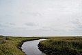 River Godel near Witsum (viewing direction south-east)
 -
 River Godel near Witsum (viewing direction north-west)


See also[edit]
References[edit]
Wikimedia Commons has media related to Godel.
- ^ Google (4 March 2019). "Godel source" (Map). Google Maps. Google. Retrieved 4 March 2019.
- ^ Google (4 March 2019). "Godel mouth" (Map). Google Maps. Google. Retrieved 4 March 2019.