
Cape Barrow (Nunavut)
Cape Barrow | |
|---|---|
.jpg) CAE schooner 'North Star' at shore in Cape Barrow | |
 Cape Barrow | |
| Coordinates: 68°01′N 110°08′W / 68.017°N 110.133°W[1] | |
| Location | Nunavut, Canada |
| Offshore water bodies | Coronation Gulf, Bathurst Inlet |
Cape Barrow is a cape which separates Coronation Gulf from Bathurst Inlet in Nunavut, Canada. It is named in honour of the Arctic explorer Sir John Barrow, 1st Baronet, and is referred to as Haninnek by the local Inuit.[2]
Along with Cape Flinders, it was named in 1821 by Sir John Franklin.[3]
Gallery[edit]
-
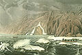 Expedition Doubling Cape Barrow, July 25, 1821, as depicted in Journey to the Shores of the Polar Sea in the years 1819, 20, 21 and 22, by John Franklin
 -
 Akana, Umingmuktogmiut woman in Cape Barrow
 -
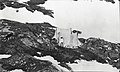 Camp in harbour at Cape Barrow, Northwest Territories (Nunavut)
 -
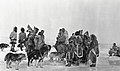 Inuit ice fishing at Cape Barrow, Northwest Territories (Nunavut)
 -
 John Raffles Cox taking latitude with sextant at harbour at Cape Barrow

.jpg)
.jpg)
.jpg)
.jpg)
References[edit]
- ^ "Cape Barrow". Geographical Names Data Base. Natural Resources Canada.
- ^ Recent Explorations on the Canadian Arctic Coast, Rudolph Martin Anderson, Geographical Review, Vol. 4, No. 4 (Oct., 1917)
- ^ McGoogan, Ken (2003). Fatal Passage: The Story of John Rae, the Arctic Hero Time Forgot. Basic Books. p. 139. ISBN 0-7867-1156-6.[permanent dead link]
This Kitikmeot Region, Nunavut location article is a stub. You can help Wikipedia by expanding it. |