
Javorani, Kneževo
Javorani | |
|---|---|
 | |
 Location of Javorani in Bosnia and Herzegovina | |
| Coordinates: 44°37′N 17°15′E / 44.617°N 17.250°E | |
| Country | Bosnia and Herzegovina |
| Division | Republika Srpska |
| Municipality | Kneževo |
| Government | |
| • Local community president | Brane Tubić (SNSD) |
| Area | |
| • Total | 25 km2 (10 sq mi) |
| Population (1991) | |
| • Total | 1,289 |
| Time zone | UTC+2 (EET) |
| • Summer (DST) | UTC+3 (EEST) |
| Postal code | 78233 |
| Area code | (+387) 51 |
Javorani (Cyrillic: Јаворани), is a village in Kneževo (Skender Vakuf) municipality, near Banja Luka, Republika Srpska, Bosnia and Herzegovina.
History[edit]
Until 1955, Javorani belonged to the former Previle Municipality, Kotor Varoš.
Population[edit]
Ethnic composition, 1991 census[edit]
| Ethnic composition of Skender Vakuf municipality, by settlements, 1991. census | ||||||
| settlement | total | Serbs | Croats | Muslims | Yugoslavs | others |
| Javorani | 1,289 | 1,273 | 1 | 0 | 6 | 9 |
References[edit]
- Official results from the book: Ethnic composition of Bosnia-Herzegovina population, by municipalities and settlements, 1991. census, Zavod za statistiku Bosne i Hercegovine - Bilten no.234, Sarajevo 1991.
Gallery[edit]
-
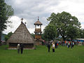 Old St. Nicholas Church from 1757.
 -
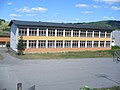 New Primary school in Javorani.
 -
 Old Primary school in Javorani.
 -
![Mountain Tisovac [sr].](//upload.wikimedia.org/wikipedia/commons/thumb/4/40/%D0%9F%D0%BB%D0%B0%D0%BD%D0%B8%D0%BD%D0%B0_%D0%A2%D0%B8%D1%81%D0%BE%D0%B2%D0%B0%D1%86_%28%D0%88%D0%B0%D0%B2%D0%BE%D1%80%D0%B0%D0%BD%D0%B8%29.jpg/120px-%D0%9F%D0%BB%D0%B0%D0%BD%D0%B8%D0%BD%D0%B0_%D0%A2%D0%B8%D1%81%D0%BE%D0%B2%D0%B0%D1%86_%28%D0%88%D0%B0%D0%B2%D0%BE%D1%80%D0%B0%D0%BD%D0%B8%29.jpg) Mountain Tisovac.
Mountain Tisovac. -
 River Kotlovac.
 -
 Winter in Javorani.
 -
 Landscape in Javorani.


![Mountain Tisovac [sr].](/wiki/File:%D0%9F%D0%BB%D0%B0%D0%BD%D0%B8%D0%BD%D0%B0_%D0%A2%D0%B8%D1%81%D0%BE%D0%B2%D0%B0%D1%86_(%D0%88%D0%B0%D0%B2%D0%BE%D1%80%D0%B0%D0%BD%D0%B8).jpg)


People from Javorani[edit]
- Lazar Tešanović - One of the Chetniks leader in Bosnia during World War II.
See also[edit]
External links[edit]
Wikimedia Commons has media related to Javorani.